1971 Map of Cusseta
USGS Topo · Published 1977About this map
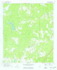
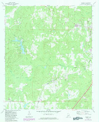
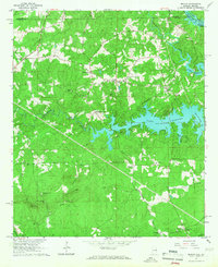
Cusseta serves as the central hub of this Chambers County landscape, situated along the tracks of the Western Railway of Alabama. The settlement pattern in the early 1970s shows a community anchored by the Cusseta Sch and the Mt Nebo Cem, with the rural surroundings defined by a network of creeks including Osanippa Creek and Wildcat Creek. To the west, the expansive Chambers County State Lake creates a significant water feature amidst the rolling terrain.
Find a feature on this map
22 named features on this map. Tap any name to fly to it.
Don’t see what you’re looking for? This feature index may not catch every label — zoom into the map to look around manually.
Map Details
Editions of this 1971 Cusseta Map
3 editions found
Other maps of this area

1907 · Opelika
USGS Topo · 1:125,000

1909 · Opelika
USGS Topo · 1:125,000

1955 · Phenix City
USGS Topo · 1:250,000

1957 · Phenix City
USGS Topo · 1:250,000

1958 · Phenix City
USGS Topo · 1:250,000
1964 · Lanett North
USGS Topo · 1:24,000
1964 · Lanett South
USGS Topo · 1:24,000
1965 · Beulah
USGS Topo · 1:24,000
1970 · Opelika East
USGS Topo · 1:24,000
1971 · Cusseta
USGS Topo · 1:24,000