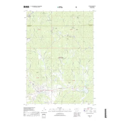
2017 Map of Custer
USGS Topo · Published 2017About this map
The Black Hills National Forest dominates this landscape, where granite spires and dense timberlands surround the established mountain community of Custer. The area is characterized by dramatic elevation shifts and narrow passages through the terrain, exemplified by technical engineering feats like the Hood Tunnel and Needles Eye Tunnel. Cultural and natural landmarks are concentrated in the northern reaches, including the iconic granite formations of The Needles and the high point at Black Elk Peak. To the south, the city of Custer serves as a gateway to local history, with its residential grid extending toward the Custer Cemetery and the waters of French Creek. Local infrastructure like Sylvan Lake Rd and Quarry Rd connects these recreation-heavy highlands, while several lakes including Sylvan Lake, Bismarck Lake, and Stockade Lake offer points of interest for those studying the region's mid-century development and tourism patterns.
Find a feature on this map
72 named features on this map. Tap any name to fly to it.
Don’t see what you’re looking for? This feature index may not catch every label — zoom into the map to look around manually.
Map Details
Editions of this 2017 Custer Map
This is the sole edition of this map. No revisions or reprints were ever made.
Other maps of this area

1894 · Hermosa
USGS Topo · 1:125,000

1896 · Harney Peak
USGS Topo · 1:125,000

1901 · Hermosa
USGS Topo · 1:125,000

1901 · Harney Peak
USGS Topo · 1:125,000

1954 · Iron Mountain
USGS Topo · 1:24,000

1954 · Fourmile
USGS Topo · 1:24,000
1954 · Mount Rushmore
USGS Topo · 1:24,000

1954 · Custer
USGS Topo · 1:24,000

1954 · Hill City
USGS Topo · 1:24,000

1954 · Berne
USGS Topo · 1:24,000