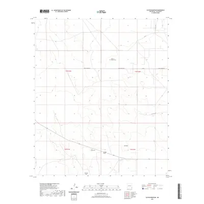
2020 Map of Custer Mountain
USGS Topo · Published 2020About this map
Custer Mtn and the nearby peak of Old Baldy dominate this southeastern New Mexico landscape, characterized by arid draws and isolated water features. The terrain is marked by seasonal drainage patterns such as Fight In Hollow Draw and Antelope Draw, while human activity is evidenced by the Jal Rifle Range and a sparse network of county roads. Local history and genealogy interest is concentrated along corridors like Cooper Cemetery Rd, which cuts through the northern townships. The presence of Old Lake and the Dinwiddie Tanks indicates the importance of managed water resources in this dry basin, where land is precisely partitioned into sections under the Public Land Survey System. The map reveals a transition between open range and the infrastructures of cattle ranching or early industrial use, with labels like Deep Wells Rd and Phillips Mill Rd hinting at the practical needs of the local economy.
Find a feature on this map
16 named features on this map. Tap any name to fly to it.
Don’t see what you’re looking for? This feature index may not catch every label — zoom into the map to look around manually.
Map Details
Editions of this 2020 Custer Mountain Map
This is the sole edition of this map. No revisions or reprints were ever made.
Other maps of this area

1954 · Hobbs
USGS Topo · 1:250,000

1958 · Hobbs
USGS Topo · 1:250,000

1963 · Oil Center
USGS Topo · 1:62,500

1969 · Jal NW
USGS Topo · 1:24,000

1969 · Jal
USGS Topo · 1:24,000

1969 · Rattlesnake Canyon
USGS Topo · 1:24,000

1973 · Javelina Basin
USGS Topo · 1:24,000

1973 · Custer Mountain
USGS Topo · 1:24,000
1973 · Andrews Place
USGS Topo · 1:24,000
1973 · Woodley Flat
USGS Topo · 1:24,000