
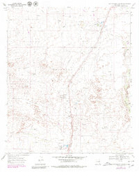
1969 Map of Rattlesnake Canyon
USGS Topo · Published 1973About this map
The Monument Oil Field dominates this 1960s landscape in Lea County, illustrating the intensive industrial development of the Permian Basin. This survey documents a complex network of oil and gas infrastructure, including a Chemical Plant, Gas Plant, and multiple pipelines that crisscross the arid terrain. Small industrial hubs like Maypens, Teague, and Johnson serve as focal points along the Texas New Mexico railroad line, which provided the essential transportation link for the region's petroleum output. The physical geography is defined by the winding course of Rattlesnake Canyon Draw, which cuts through the plateau, while numerous gravel pits suggest ongoing road construction and maintenance to support the field's heavy vehicle traffic. This map captures the region at a peak of energy production, characterized by Radio Towers and electrical substations powering the remote operations.
Find a feature on this map
15 named features on this map. Tap any name to fly to it.
Don’t see what you’re looking for? This feature index may not catch every label — zoom into the map to look around manually.
Map Details
Editions of this 1969 Rattlesnake Canyon Map
2 editions found
Other maps of this area

1954 · Hobbs
USGS Topo · 1:250,000

1958 · Hobbs
USGS Topo · 1:250,000

1963 · Oil Center
USGS Topo · 1:62,500

1969 · Jal NE
USGS Topo · 1:24,000

1969 · Eunice
USGS Topo · 1:24,000

1969 · Eunice NE
USGS Topo · 1:24,000

1969 · Eunice SE
USGS Topo · 1:24,000

1969 · Jal NW
USGS Topo · 1:24,000

1973 · Custer Mountain
USGS Topo · 1:24,000

1978 · Jal
USGS Topo · 1:100,000