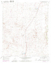
1969 Map of Rattlesnake Canyon
USGS Topo · Published 1980About this map
The Monument Oil Field dominates this landscape in Lea County, illustrating the intensive industrial development of southeastern New Mexico during the late 1960s. A dense network of oil wells, gas wells, and a sprawling pipeline system defines the area's economic character, supported by a Chemical Plant and multiple gas plants. Transport for these petroleum resources is anchored by the Texas New Mexico rail line, which runs northeast to southwest across the terrain. Small specialized settlements such as Teague, Sims, and Maypens appear as crucial nodes within this energy-producing corridor. Beyond the industrial footprint, the natural topography is marked by the winding courses of Rattlesnake Canyon and Monument Draw, which cut through the high desert. Industrial landmarks like Radio Towers, a Water Tank, and a Substation serve as practical navigational points for researchers tracing the mid-century infrastructure of the Permian Basin.
Find a feature on this map
18 named features on this map. Tap any name to fly to it.
Don’t see what you’re looking for? This feature index may not catch every label — zoom into the map to look around manually.
Map Details
Editions of this 1969 Rattlesnake Canyon Map
2 editions found
Other maps of this area

1954 · Hobbs
USGS Topo · 1:250,000

1958 · Hobbs
USGS Topo · 1:250,000

1963 · Oil Center
USGS Topo · 1:62,500

1969 · Jal NE
USGS Topo · 1:24,000

1969 · Eunice
USGS Topo · 1:24,000

1969 · Eunice NE
USGS Topo · 1:24,000

1969 · Eunice SE
USGS Topo · 1:24,000

1969 · Jal NW
USGS Topo · 1:24,000

1969 · Rattlesnake Canyon
USGS Topo · 1:24,000

1973 · Custer Mountain
USGS Topo · 1:24,000