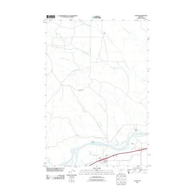
2011 Map of Custer
USGS Topo · Published 2011About this map
The Yellowstone River snakes through the southern portion of this landscape, defining the geographic heart of the Custer vicinity. To the north, the terrain transitions into a series of dissected uplands drained by the intricate branches of North Fork Allen Creek, Middle Fork Allen Creek, and South Fork Allen Creek. Landmarks like Fivemile Hill and Big Coulee dominate the topography, while the historic Musselshell Trail Rd and Pease Bottom Rd trace old overland routes through the river valley. The map details localized infrastructure and aviation history at Ruff Airport and includes the Bighorn Tunnel along the river corridor, illustrating the area's role as a transportation passage. Local services are centered around the Custer Vol Fire Dept, providing a look at the rural community structure in Yellowstone County during the early 21st century.
Find a feature on this map
20 named features on this map. Tap any name to fly to it.
Don’t see what you’re looking for? This feature index may not catch every label — zoom into the map to look around manually.
Map Details
Editions of this 2011 Custer Map
This is the sole edition of this map. No revisions or reprints were ever made.
Other maps of this area

1954 · Forsyth
USGS Topo · 1:250,000

1957 · Forsyth
USGS Topo · 1:250,000

1958 · Forsyth
USGS Topo · 1:250,000

1960 · Bighorn
USGS Topo · 1:24,000

1960 · Coal Bank Creek
USGS Topo · 1:24,000

1960 · Custer
USGS Topo · 1:24,000

1960 · Rancher Cemetery
USGS Topo · 1:24,000

1960 · Marsh Coulee
USGS Topo · 1:24,000

1960 · Waco
USGS Topo · 1:24,000
1960 · Mission Creek
USGS Topo · 1:24,000