
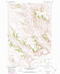
1960 Map of Rancher Cemetery
USGS Topo · Published 1962About this map
Rancher Cemetery sits at the edge of the expansive Pease Bottom lowland, a distinct geographical feature in this part of Treasure County. The landscape is defined by the winding paths of Muggins Creek and Alkali Creek, which carve through the terrain as they move toward the larger river valley system. These watercourses, along with the North Fork Edwards Creek, dictate the movement and settlement patterns of the area, providing the necessary water sources for ranching operations in a semi-arid environment.
Find a feature on this map
8 named features on this map. Tap any name to fly to it.
Don’t see what you’re looking for? This feature index may not catch every label — zoom into the map to look around manually.
Map Details
Editions of this 1960 Rancher Cemetery Map
2 editions found
Other maps of this area

1954 · Forsyth
USGS Topo · 1:250,000

1957 · Forsyth
USGS Topo · 1:250,000

1958 · Forsyth
USGS Topo · 1:250,000

1960 · Bighorn
USGS Topo · 1:24,000

1960 · Steie Ranch
USGS Topo · 1:24,000

1960 · Custer
USGS Topo · 1:24,000

1960 · Myers
USGS Topo · 1:24,000

1960 · Eldering Ranch
USGS Topo · 1:24,000

1960 · Mc Konkey Creek
USGS Topo · 1:24,000

1979 · Hysham
USGS Topo · 1:100,000