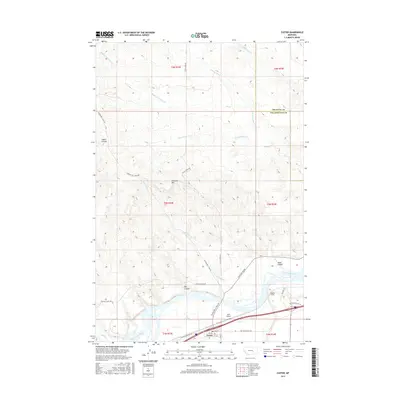
2017 Map of Custer
USGS Topo · Published 2017About this map
The town of Custer sits prominently along the northern bank of the Yellowstone River, serving as a focal point for the surrounding prairie and river-bottom landscape. This 2017 study illustrates the intersection of historical transport and modern infrastructure, where the Bighorn Tunnel and Old Hwy 10 parallel the river's course. The terrain north of the valley is defined by significant drainage systems such as Fivemile Cr and Buffalo Cr, which carve through the land alongside Laylan Coulee and Big Coulee. Local transportation is anchored by historic routes like Musselshell Trail Rd and Pease Bottom Rd. The inclusion of Ruff Airport and several township boundaries, including the line between Treasure and Yellowstone Counties, provides a clear view of the regional administrative and aviation footprint near Fivemile Hill.
Find a feature on this map
33 named features on this map. Tap any name to fly to it.
Don’t see what you’re looking for? This feature index may not catch every label — zoom into the map to look around manually.
Map Details
Editions of this 2017 Custer Map
This is the sole edition of this map. No revisions or reprints were ever made.
Other maps of this area

1954 · Forsyth
USGS Topo · 1:250,000

1957 · Forsyth
USGS Topo · 1:250,000

1958 · Forsyth
USGS Topo · 1:250,000

1960 · Bighorn
USGS Topo · 1:24,000

1960 · Coal Bank Creek
USGS Topo · 1:24,000

1960 · Custer
USGS Topo · 1:24,000

1960 · Rancher Cemetery
USGS Topo · 1:24,000

1960 · Marsh Coulee
USGS Topo · 1:24,000

1960 · Waco
USGS Topo · 1:24,000
1960 · Mission Creek
USGS Topo · 1:24,000