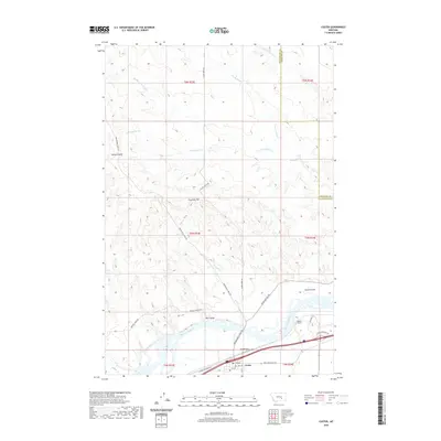
2020 Map of Custer
USGS Topo · Published 2020About this map
The Yellowstone River anchors the southern portion of this landscape as it flows through the valley near Custer. The town's layout is defined by a grid including 2nd Ave and 3rd Ave, situated between the river and the Custer Frontage Rd. North of the settlement, the terrain transitions into a complex system of drainage basins and ridges, notably around Fivemile Hill and Big Coulee. Significant historical movement through this region is traced by the Musselshell Trail Rd and Pease Bottom Rd, which wind through the breaks and coulees. Transportation infrastructure is further represented by the Bighorn Tunnel and the small Ruff Airport, reflecting the area's continued role as a corridor for travel and ranching between the Yellowstone and the high ground of the Treasure County and Yellowstone County border.
Find a feature on this map
33 named features on this map. Tap any name to fly to it.
Don’t see what you’re looking for? This feature index may not catch every label — zoom into the map to look around manually.
Map Details
Editions of this 2020 Custer Map
This is the sole edition of this map. No revisions or reprints were ever made.
Other maps of this area

1954 · Forsyth
USGS Topo · 1:250,000

1957 · Forsyth
USGS Topo · 1:250,000

1958 · Forsyth
USGS Topo · 1:250,000

1960 · Bighorn
USGS Topo · 1:24,000

1960 · Coal Bank Creek
USGS Topo · 1:24,000

1960 · Custer
USGS Topo · 1:24,000

1960 · Rancher Cemetery
USGS Topo · 1:24,000

1960 · Marsh Coulee
USGS Topo · 1:24,000

1960 · Waco
USGS Topo · 1:24,000
1960 · Mission Creek
USGS Topo · 1:24,000