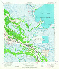
1963 Map of Cut Off
USGS Topo · Published 1964About this map
Lafourche serves as the central artery for this coastal landscape in the early 1960s, anchoring a chain of ribbon settlements including Valentine, Ludevine, Larose, and Cut Off. The map reveals a transition from these historic bankside communities to the sprawling agricultural and industrial operations of Delta Farms and Clovelly Farms. Beyond the reclaimed lands, a dense network of waterways like Bayou Portuguese and Bayou Long weaves through the wetlands toward the expanse of Lake Salvador. Local life is detailed through landmarks such as Gheens Ch, Griffin Cem, and Mt Zion Sch, alongside industrial indicators like the Bayou Poignard Gas Field. The presence of the Southern Pacific railroad and the Intracoastal Waterway highlights the region's importance as a transportation corridor connecting the marshlands to broader commerce.
Find a feature on this map
60 named features on this map. Tap any name to fly to it.
Don’t see what you’re looking for? This feature index may not catch every label — zoom into the map to look around manually.
Map Details
Editions of this 1963 Cut Off Map
3 editions found
Other maps of this area

1891 · Hahnville
USGS Topo · 1:62,500

1891 · New Orleans
USGS Topo · 1:62,500

1892 · Barataria
USGS Topo · 1:62,500

1892 · Lac Des Allemands
USGS Topo · 1:62,500

1892 · Cut-Off
USGS Topo · 1:62,500

1892 · Houma
USGS Topo · 1:62,500

1892 · Creole
USGS Topo · 1:62,500

1894 · Lake Felicity
USGS Topo · 1:62,500

1894 · Dulac
USGS Topo · 1:62,500

1932 · Houma SE
USGS Topo · 1:31,680