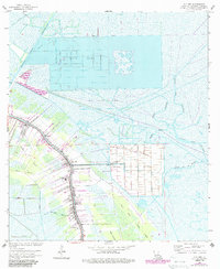
1963 Map of Cut Off
USGS Topo · Published 1988About this map
Larose and Cut Off serve as the primary hubs of activity along the bayou in this early 1960s survey of Lafourche Parish. The settlement pattern follows the natural levee system, with a dense corridor of homes and businesses lining the Bayou and the Intracoastal Waterway Larose. Beyond the inhabited strips, the landscape is defined by massive reclamation and industrial efforts, including the geometric grids of Delta Farms and Clovelly Farms, alongside the sprawling Bayou Poignard Gas Field.
Find a feature on this map
35 named features on this map. Tap any name to fly to it.
Don’t see what you’re looking for? This feature index may not catch every label — zoom into the map to look around manually.
Map Details
Editions of this 1963 Cut Off Map
4 editions found

Other maps of this area

1892 · Barataria
USGS Topo · 1:62,500

1892 · Cut-Off
USGS Topo · 1:62,500

1892 · Creole
USGS Topo · 1:62,500

1894 · Lake Felicity
USGS Topo · 1:62,500

1935 · Viguerie Canal
USGS Topo · 1:31,680

1935 · Golden Meadow
USGS Topo · 1:31,680

1939 · Cut-Off
USGS Topo · 1:62,500

1939 · Lake Felicity
USGS Topo · 1:62,500

1941 · Cut-Off
USGS Topo · 1:62,500

1941 · Lake Felicity
USGS Topo · 1:62,500