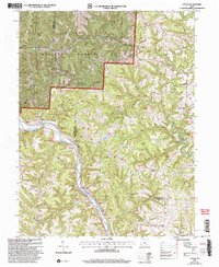
2002 Map of Cutler
USGS Topo · Published 2006About this map
Wayne National Forest land dominates the northern terrain of this quadrangle, where the border between Athens and Washington counties winds through a landscape of steep ridges and creek valleys. The village of Cutler serves as a local hub near the Cutler School, while smaller settlements like Decaturville and Frost are connected by a network of forest roads, including fr5 and fr12. This 2002 revision shows the persistence of rural life through its numerous family and church burial grounds, such as the Finsterwald Cemetery, Grippen Cemetery, and Ladd Cemetery.
Find a feature on this map
67 named features on this map. Tap any name to fly to it.
Don’t see what you’re looking for? This feature index may not catch every label — zoom into the map to look around manually.
Map Details
Editions of this 2002 Cutler Map
This is the sole edition of this map. No revisions or reprints were ever made.
Other maps of this area

1902 · Parkersburg
USGS Topo · 1:62,500

1904 · Parkersburg
USGS Topo · 1:62,500

1904 · Chesterhill
USGS Topo · 1:62,500

1906 · Belleville
USGS Topo · 1:62,500

1906 · Chesterhill
USGS Topo · 1:62,500

1907 · Keno
USGS Topo · 1:62,500

1924 · Belleville
USGS Topo · 1:62,500

1926 · Belleville
USGS Topo · 1:62,500

1949 · Clarksburg
USGS Topo · 1:250,000

1956 · Clarksburg
USGS Topo · 1:250,000