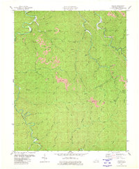
1980 Map of Cutshin
USGS Topo · Published 1980About this map
The Middle Fork Kentucky River and Greasy Creek carve through this section of Leslie County, defining a landscape dominated by the coal industry and isolated mountain settlements. In this 1980 edition, pink-shaded Strip Mines are prominent across the ridges, particularly north of Bad Creek and surrounding Hensley Branch, illustrating the scale of surface mining in the Eastern Kentucky Coalfield during the late 20th century.
Find a feature on this map
72 named features on this map. Tap any name to fly to it.
Don’t see what you’re looking for? This feature index may not catch every label — zoom into the map to look around manually.
Map Details
Editions of this 1980 Cutshin Map
This is the sole edition of this map. No revisions or reprints were ever made.
Other maps of this area

1887 · Jonesville
USGS Topo · 1:125,000

1891 · Hazard
USGS Topo · 1:125,000

1891 · Jonesville
USGS Topo · 1:125,000

1903 · Harlan
USGS Topo · 1:48,000

1916 · Cornettsville
USGS Topo · 1:62,500

1916 · Harlan
USGS Topo · 1:48,000

1916 · Nolansburg
USGS Topo · 1:48,000

1916 · Hyden
USGS Topo · 1:48,000

1919 · Nolansburg
USGS Topo · 1:62,500

1919 · Hyden
USGS Topo · 1:62,500