
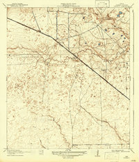
1918 Map of Cypress
USGS Topo · Published 1918About this map
The settlement of Cypress serves as the focal point for this Harris County survey, situated where the Houston and Hempstead Road crosses the fertile drainage of Big Cypress Creek. This era in Southeast Texas reveals a landscape of ranching and early commerce, evidenced by the presence of Rams Ranch and the localized development at Houston Hot Wells. The map highlights a community-centric infrastructure, with rural education centers like the Big Cypress School and Brink School serving the surrounding homesteads.
Find a feature on this map
17 named features on this map. Tap any name to fly to it.
Don’t see what you’re looking for? This feature index may not catch every label — zoom into the map to look around manually.
Map Details
Editions of this 1918 Cypress Map
2 editions found
Other maps of this area

1915 · Cypress
USGS Topo · 1:24,000

1915 · Katy
USGS Topo · 1:24,000

1915 · Addicks
USGS Topo · 1:24,000

1915 · Hillendahl
USGS Topo · 1:24,000

1916 · Rose Hill
USGS Topo · 1:24,000

1916 · Louetta
USGS Topo · 1:24,000

1916 · Hockley
USGS Topo · 1:24,000

1916 · Satsuma
USGS Topo · 1:24,000

1916 · Swanson
USGS Topo · 1:24,000

1918 · Addicks
USGS Topo · 1:31,680