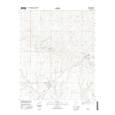
2016 Map of Cyril
USGS Topo · Published 2016About this map
Cyril and Cement anchor this section of Caddo County, Oklahoma, where the landscape is defined by a complex network of managed waterways and seasonal creeks. The Little Washita River winds through the southern portion of the area, supported by multiple flood control structures such as the Little Washita Creek Site 27 Reservoir and Little Washita Cr Site 49 Reservoir. These reservoirs, along with Tonkawa Creek Site 1a Reservoir to the northwest, illustrate the regional infrastructure required to manage the drainage basins of Delaware Creek and its many tributaries.
Find a feature on this map
53 named features on this map. Tap any name to fly to it.
Don’t see what you’re looking for? This feature index may not catch every label — zoom into the map to look around manually.
Map Details
Editions of this 2016 Cyril Map
This is the sole edition of this map. No revisions or reprints were ever made.
Other maps of this area

1945 · Anadarko
USGS Topo · 1:62,500

1949 · Cement
USGS Topo · 1:62,500

1949 · Elgin
USGS Topo · 1:24,000

1951 · Fort Cobb
USGS Topo · 1:62,500

1955 · Lawton
USGS Topo · 1:250,000

1955 · Clinton
USGS Topo · 1:250,000

1956 · Laverty
USGS Topo · 1:24,000

1956 · Fletcher
USGS Topo · 1:24,000
1956 · Rocky Ford
USGS Topo · 1:24,000

1956 · Elgin
USGS Topo · 1:24,000