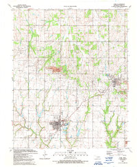
1991 Map of Cyril
USGS Topo · Published 1991About this map
Extensive petroleum and gas infrastructure dominates the landscape between Cyril and Cement in this 1991 topographic record. The survey illustrates a region defined by its natural resources, featuring a large Oil And Gas Field that stretches across the northern and central portions of the quadrangle. Industrial landmarks such as a large Quarry, multiple Gas Wells, a Pumping Station, and Sludge Pits highlight the local extractive economy.
Find a feature on this map
20 named features on this map. Tap any name to fly to it.
Don’t see what you’re looking for? This feature index may not catch every label — zoom into the map to look around manually.
Map Details
Editions of this 1991 Cyril Map
This is the sole edition of this map. No revisions or reprints were ever made.
Other maps of this area

1945 · Anadarko
USGS Topo · 1:62,500

1949 · Cement
USGS Topo · 1:62,500

1949 · Elgin
USGS Topo · 1:24,000

1951 · Fort Cobb
USGS Topo · 1:62,500

1955 · Lawton
USGS Topo · 1:250,000

1955 · Clinton
USGS Topo · 1:250,000

1956 · Laverty
USGS Topo · 1:24,000

1956 · Fletcher
USGS Topo · 1:24,000
1956 · Rocky Ford
USGS Topo · 1:24,000

1956 · Elgin
USGS Topo · 1:24,000