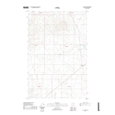
2020 Map of D Y Junction
USGS Topo · Published 2020About this map
Dy Junction serves as the focal point for this section of Phillips County, where the intersection of rural routes marks a quiet crossing in the Montana plains. The landscape is defined by an intricate drainage system including Siparyann Cr, Duval Cr, and Little Cottonwood Cr, which carve through the terrain toward the Missouri River basin to the south. Historically significant travel ways like Power Plant Ferry Rd and the C M R Auto Nature Tour Rd suggest the area's role in regional connectivity and conservation near the Charles M. Russell National Wildlife Refuge. Water remains a critical element for local ranching and land use, evidenced by the presence of Phillips Reservoir and Mud Spring amidst the vast rangeland and coulees.
Find a feature on this map
19 named features on this map. Tap any name to fly to it.
Don’t see what you’re looking for? This feature index may not catch every label — zoom into the map to look around manually.
Map Details
Editions of this 2020 D Y Junction Map
This is the sole edition of this map. No revisions or reprints were ever made.
Other maps of this area
1943 · Landusky
USGS Topo · 1:125,000
1954 · Bell Ridge East
USGS Topo · 1:24,000
1954 · Bell Ridge West
USGS Topo · 1:24,000
1954 · Grand Island
USGS Topo · 1:24,000
1954 · Lewistown
USGS Topo · 1:250,000
1959 · Lewistown
USGS Topo · 1:250,000
1971 · Crazyman Coulee
USGS Topo · 1:24,000
1971 · Hays
USGS Topo · 1:24,000
1971 · Hays SE
USGS Topo · 1:24,000
1971 · Zortman
USGS Topo · 1:24,000