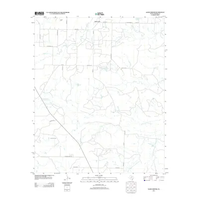
2012 Map of Dads Corner
USGS Topo · Published 2012About this map
The settlement of Dads Corner serves as the central point for this Archer County landscape, where the prairie transitions into a network of ranch roads and water management features. The area's history is deeply tied to the petroleum industry, evidenced by the Turbeville Oil Field and the Continental Oil Company Reservoir in the western reaches. Water distribution is critical here, with several named drainages including the N Fork Little Wichita River and Middle Fork Little Wichita River winding through the terrain, alongside smaller storage features like Windmill Tank and the Cole Storage Tank. Genealogists and local historians can locate the Stewart Cem in the northwest, near the intersection of Britton Ln and Gravel Rd, marking a quiet historical anchor in this sparsely populated region of North Texas.
Find a feature on this map
29 named features on this map. Tap any name to fly to it.
Don’t see what you’re looking for? This feature index may not catch every label — zoom into the map to look around manually.
Map Details
Editions of this 2012 Dads Corner Map
This is the sole edition of this map. No revisions or reprints were ever made.
Other maps of this area

1931 · Archer City
USGS Topo · 1:62,500

1932 · Dundee
USGS Topo · 1:62,500

1954 · Wichita Falls
USGS Topo · 1:250,000

1956 · Lake Wichita
USGS Topo · 1:24,000

1957 · Wichita Falls West
USGS Topo · 1:62,500

1958 · Wichita Falls
USGS Topo · 1:250,000
1963 · Archer City NE
USGS Topo · 1:24,000

1963 · Archer City East
USGS Topo · 1:24,000

1964 · Dundee SE
USGS Topo · 1:24,000

1964 · Archer City West
USGS Topo · 1:24,000