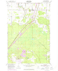
1951 Map of Dafter
USGS Topo · Published 1977About this map
The Kincheloe Air Force Base anchor the southern portion of this Chippewa County landscape, reflecting the military's strategic footprint in the Upper Peninsula during the mid-20th century. To the north, the small settlement of Dafter serves as a local hub, situated near the Methodist Ch and the Christie Sch. The region's transport network is defined by the Minneapolis St Paul and Sault Ste Marie and Soo Line railroads, which cut diagonally across the terrain to facilitate timber and freight movement. Much of the central acreage is dedicated to the Munuscong State Forest, where the Little Munuscong River and South Branch East Branch Waiska River drain the wooded lowlands. These watercourses, along with smaller bodies like Riordan Lake, characterize a geography still largely defined by its natural resources and the infrastructure of the Cold War era.
Find a feature on this map
26 named features on this map. Tap any name to fly to it.
Don’t see what you’re looking for? This feature index may not catch every label — zoom into the map to look around manually.
Map Details
Editions of this 1951 Dafter Map
2 editions found
Other maps of this area

1913 · Sault Sainte Marie
USGS Topo · 1:62,500

1941 · Sault Sainte Marie
USGS Topo · 1:63,360

1941 · Brimley
USGS Topo · 1:63,360

1951 · Shallows
USGS Topo · 1:24,000

1951 · Kinross
USGS Topo · 1:24,000

1951 · Dafter
USGS Topo · 1:24,000

1951 · Barbeau
USGS Topo · 1:24,000

1951 · Brimley
USGS Topo · 1:62,500

1951 · Sault Ste. Marie
USGS Topo · 1:62,500

1951 · Brimley
USGS Topo · 1:24,000