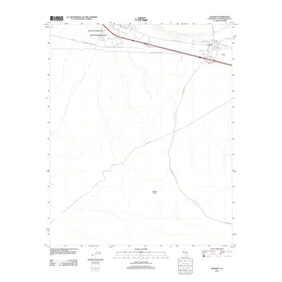
2012 Map of Daggett
USGS Topo · Published 2012About this map
Daggett stands at a historic crossroads in the Mojave Desert, where the path of the Mojave River and the National Trails Hwy intersect with the legacy of the Old West and mid-century military expansion. The map details the proximity of the Barstow MC Logistics Base, including the Eniwetok Housing Area and Desert View Housing Area, illustrating the desert’s role in modern logistical operations. Genealogists and local historians can locate the Daggett Cem and the local post office, which remain as vital anchors for this small community. South of the town, the terrain rises toward Daggett Ridge, while the landscape is carved by the long course of Daggett Wash, showing how natural drainage and infrastructure like the Power Line Rd and various pipelines have shaped the development of this arid San Bernardino County corridor.
Find a feature on this map
21 named features on this map. Tap any name to fly to it.
Don’t see what you’re looking for? This feature index may not catch every label — zoom into the map to look around manually.
Map Details
Editions of this 2012 Daggett Map
This is the sole edition of this map. No revisions or reprints were ever made.
Other maps of this area

1932 · Barstow
USGS Topo · 1:125,000

1934 · Barstow
USGS Topo · 1:125,000

1953 · San Bernardino
USGS Topo · 1:250,000

1953 · Yermo
USGS Topo · 1:24,000
1953 · Nebo
USGS Topo · 1:24,000

1955 · Ord Mountains
USGS Topo · 1:62,500

1956 · San Bernardino
USGS Topo · 1:250,000

1956 · Daggett
USGS Topo · 1:62,500

1956 · Barstow
USGS Topo · 1:62,500

1957 · Apple Valley
USGS Topo · 1:62,500