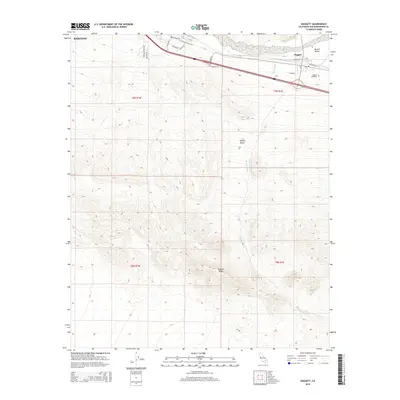
2015 Map of Daggett
USGS Topo · Published 2015About this map
Daggett sits at a critical junction of desert travel where the Mojave River carves through the Mojave Valley. This 2015 perspective illustrates the enduring importance of this corridor, where the historic National Trails Hwy and Santa Fe St parallel the rail lines that defined the town's early role as a freight hub. To the south, the terrain rises sharply into Daggett Ridge, a stark contrast to the alluvial plains of Daggett Wash. The town's military and logistical heritage is evidenced by street names like S Iwo Jima St, Tarawa Ave, and Cape Gloucester Ave, reflecting the footprint of nearby base operations. Genealogists will find the Daggett Cemetery clearly marked on the eastern edge of the settlement, while the northwestern corner shows the expanding reach of Barstow along the river valley floor.
Find a feature on this map
27 named features on this map. Tap any name to fly to it.
Don’t see what you’re looking for? This feature index may not catch every label — zoom into the map to look around manually.
Map Details
Editions of this 2015 Daggett Map
This is the sole edition of this map. No revisions or reprints were ever made.
Other maps of this area

1932 · Barstow
USGS Topo · 1:125,000

1934 · Barstow
USGS Topo · 1:125,000

1953 · San Bernardino
USGS Topo · 1:250,000

1953 · Yermo
USGS Topo · 1:24,000
1953 · Nebo
USGS Topo · 1:24,000

1955 · Ord Mountains
USGS Topo · 1:62,500

1956 · San Bernardino
USGS Topo · 1:250,000

1956 · Daggett
USGS Topo · 1:62,500

1956 · Barstow
USGS Topo · 1:62,500

1957 · Apple Valley
USGS Topo · 1:62,500