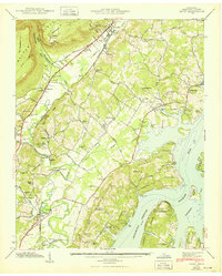
1943 Map of Daisy
USGS Topo · Published 1950About this map
The Southern Railway corridor anchors this 1942 Tennessee Valley Authority survey of Hamilton County, documenting a landscape at the height of New Deal-era transformation. The newly formed Chickamauga Reservoir has fundamentally reshaped the eastern landscape, submerging the former banks of the Tennessee River and creating Harrison Bay. While the reservoir introduced recreational areas like the Chattanooga Rod and Gun Club and Fairview Cabin Site Area, the interior remains a network of traditional rural settlements. Communities such as Daisy and Hixson are defined by family-named landmarks and local institutions, including Burks Chapel, Middle Valley Sch, and numerous family burial grounds like Barker Cem. The industrial footprint of the era is preserved in the kilns near Melville and the Aerial Tramway ascending Walden Ridge toward Montlake.
Find a feature on this map
78 named features on this map. Tap any name to fly to it.
Don’t see what you’re looking for? This feature index may not catch every label — zoom into the map to look around manually.
Map Details
Editions of this 1943 Daisy Map
2 editions found
Other maps of this area

1888 · Chattanooga
USGS Topo · 1:125,000

1893 · Chattanooga
USGS Topo · 1:125,000

1935 · East Chattanooga
USGS Topo · 1:24,000

1935 · Daisy
USGS Topo · 1:24,000

1935 · Soddy
USGS Topo · 1:24,000

1935 · Snow Hill
USGS Topo · 1:24,000

1935 · Ooltewah
USGS Topo · 1:24,000

1935 · Soddy Island
USGS Topo · 1:24,000

1936 · Henson Gap
USGS Topo · 1:24,000

1936 · Fairmount
USGS Topo · 1:24,000