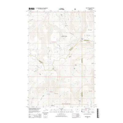
2014 Map of Daisy Peak
USGS Topo · Published 2014About this map
Lewis & Clark National Forest encompasses the high country of the Little Belt Mountains where the borders of Meagher, Judith Basin, and Wheatland counties meet. This 2014 survey documents a landscape defined by deep drainages and prominent summits, including Burley Peak and Daisy Peak. The hydrology of the area is complex, with the S Fork Judith River and its numerous tributaries like Cabin Creek and Bluff Mountain Creek carving through the terrain. The map captures distinct geographic landmarks such as the Daisy Notch and Daisy Narrows, alongside high-elevation clearings like Haymaker Park and Johnson Park. In the eastern section, Mt High rises above Antelope Gorge, marking a significant elevation point within this protected forest boundary. The transition from steep peaks to lower-lying coulees, such as Quaking Aspen Coulee, illustrates the drainage patterns characteristic of this part of Montana.
Find a feature on this map
45 named features on this map. Tap any name to fly to it.
Don’t see what you’re looking for? This feature index may not catch every label — zoom into the map to look around manually.
Map Details
Editions of this 2014 Daisy Peak Map
This is the sole edition of this map. No revisions or reprints were ever made.
Other maps of this area

1886 · Little Belt Mts.
USGS Topo · 1:250,000

1894 · Little Belt Mts.
USGS Topo · 1:250,000

1897 · Little Belt Mts.
USGS Topo · 1:250,000

1898 · Little Belt Mts.
USGS Topo · 1:250,000

1902 · Little Belt Mts.
USGS Topo · 1:250,000

1948 · White Sulphur Springs
USGS Topo · 1:250,000

1958 · White Sulphur Springs
USGS Topo · 1:250,000

1961 · White Sulphur Springs
USGS Topo · 1:250,000

1965 · White Sulphur Springs
USGS Topo · 1:250,000
1970 · Ettien Spring
USGS Topo · 1:24,000