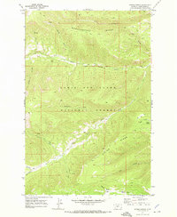
1970 Map of Ettien Spring
USGS Topo · Published 1973About this map
Lewis and Clark National Forest defines the rugged topography of this Judith Basin landscape, where high elevations and deep drainage basins are interconnected by primitive travel routes. The 1970 field survey documents a remote wilderness environment before modern development, characterized by a complex network of Jeep Trails and Pack Trails that navigate the steep elevations of Woodchopper Ridge and Ettien Ridge. Settlement is sparse and largely transient, represented by landmark outposts like Korell Cabin near Deer Gulch and Burris Cabin along the upper reaches of the Middle Fork Judith River. Water sources are critical identifiers in this terrain, with named features such as Ettien Spring and Russian Spring Creek serving as vital landmarks for those traversing the forest interior. This map provides a detailed view of the natural hydrology of the area, including the winding paths of Sandpoint Creek and Lost Fork as they carve through the mountain canyons.
Find a feature on this map
24 named features on this map. Tap any name to fly to it.
Don’t see what you’re looking for? This feature index may not catch every label — zoom into the map to look around manually.
Map Details
Editions of this 1970 Ettien Spring Map
2 editions found
Other maps of this area

1886 · Little Belt Mts.
USGS Topo · 1:250,000

1894 · Little Belt Mts.
USGS Topo · 1:250,000

1897 · Little Belt Mts.
USGS Topo · 1:250,000

1898 · Little Belt Mts.
USGS Topo · 1:250,000

1902 · Little Belt Mts.
USGS Topo · 1:250,000

1948 · White Sulphur Springs
USGS Topo · 1:250,000

1958 · White Sulphur Springs
USGS Topo · 1:250,000

1961 · White Sulphur Springs
USGS Topo · 1:250,000
1961 · Yogo Peak
USGS Topo · 1:24,000
1961 · Sand Point
USGS Topo · 1:24,000