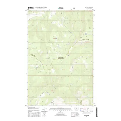
2017 Map of Daisy Peak
USGS Topo · Published 2017About this map
Lewis & Clark National Forest encompasses the majority of this high-elevation terrain where the borders of Meagher, Judith Basin, and Wheatland Counties converge. The landscape is defined by its dramatic verticality, rising from the S Fork Judith River in the northwest to prominent summits like Burley Peak and Mt High. This 2017 survey reveals a network of primitive forest access routes, such as Findon Lane Rd and Daisy Sale Lp, which navigate through deeply carved drainages including Antelope Gorge and Trask Gulch. High-country clearings like Haymaker Park and Johnson Park sit amidst a complex of peaks including Daisy Peak and Bluff Mtn. The hydrology of the area is distinct, with numerous seasonal and perennial forks like Daisy Dean Cr and the W Fork Nevada Cr cutting through geological breaks like Daisy Notch and Nevada Narrows.
Find a feature on this map
51 named features on this map. Tap any name to fly to it.
Don’t see what you’re looking for? This feature index may not catch every label — zoom into the map to look around manually.
Map Details
Editions of this 2017 Daisy Peak Map
This is the sole edition of this map. No revisions or reprints were ever made.
Other maps of this area

1886 · Little Belt Mts.
USGS Topo · 1:250,000

1894 · Little Belt Mts.
USGS Topo · 1:250,000

1897 · Little Belt Mts.
USGS Topo · 1:250,000

1898 · Little Belt Mts.
USGS Topo · 1:250,000

1902 · Little Belt Mts.
USGS Topo · 1:250,000

1948 · White Sulphur Springs
USGS Topo · 1:250,000

1958 · White Sulphur Springs
USGS Topo · 1:250,000

1961 · White Sulphur Springs
USGS Topo · 1:250,000

1965 · White Sulphur Springs
USGS Topo · 1:250,000
1970 · Ettien Spring
USGS Topo · 1:24,000