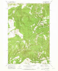
1972 Map of Daisy Peak
USGS Topo · Published 1975About this map
The Lewis and Clark National Forest encompasses this high-altitude landscape where the headwaters of the Judith River begin their descent. This 1970s survey highlights the rugged backcountry at the junction of Judith Basin and Meagher counties, centered on the prominent Daisy Peak and the pass at Daisy Notch. The area is characterized by a sophisticated network of historical movement, including the Smith Creek Pack Trail and Morris Creek Pack Trail, which were essential for managing these timbered slopes and alpine meadows. A significant point for local history is the Daisy Guard Sta (Site), appearing here as a former outpost of forest administration. The terrain is marked by distinctive geographical features like the Nevada Narrows and the Daisy Narrows, where watercourses like Daisy Dean Creek have cut through the limestone and shale formations of the Little Belt Mountains.
Find a feature on this map
40 named features on this map. Tap any name to fly to it.
Don’t see what you’re looking for? This feature index may not catch every label — zoom into the map to look around manually.
Map Details
Editions of this 1972 Daisy Peak Map
This is the sole edition of this map. No revisions or reprints were ever made.
Other maps of this area

1886 · Little Belt Mts.
USGS Topo · 1:250,000

1894 · Little Belt Mts.
USGS Topo · 1:250,000

1897 · Little Belt Mts.
USGS Topo · 1:250,000

1898 · Little Belt Mts.
USGS Topo · 1:250,000

1902 · Little Belt Mts.
USGS Topo · 1:250,000

1948 · White Sulphur Springs
USGS Topo · 1:250,000

1958 · White Sulphur Springs
USGS Topo · 1:250,000

1961 · White Sulphur Springs
USGS Topo · 1:250,000

1965 · White Sulphur Springs
USGS Topo · 1:250,000
1970 · Ettien Spring
USGS Topo · 1:24,000