
1961 Map of Dalbo
USGS Topo · Published 1963About this map
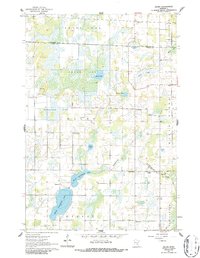
The South Fork of the Rum River defines the northern drainage of this Minnesota landscape, where the Kanabec Co Isanti Co line marks the boundary between rural townships. The southern portion is dominated by the connected waters of North Stanchfield Lake and South Stanchfield Lake, feeding into Stanchfield Creek as it winds toward the settlement of Dalbo. This area is characterized by significant wetlands, most notably the expansive Krone Bog and Odegard Bog, which influenced the placement of early infrastructure. Rural social centers are well-documented through a dense network of country schools, including North Star Sch, Lincoln Sch, and Hawthorne Sch. Local history and genealogy are preserved in the locations of Salem Ch and its adjacent Salem Cem, as well as the community Grange Hall located centrally within the quadrangle.
Find a feature on this map
34 named features on this map. Tap any name to fly to it.
Don’t see what you’re looking for? This feature index may not catch every label — zoom into the map to look around manually.
Map Details
Editions of this 1961 Dalbo Map
2 editions found
Other maps of this area

1953 · Stillwater
USGS Topo · 1:250,000

1955 · Stillwater
USGS Topo · 1:250,000

1958 · Stillwater
USGS Topo · 1:250,000

1961 · Bradford
USGS Topo · 1:24,000

1961 · Springvale
USGS Topo · 1:24,000

1961 · Wyanett
USGS Topo · 1:24,000

1961 · Dalbo
USGS Topo · 1:62,500

1965 · Stillwater
USGS Topo · 1:250,000
1968 · Princeton
USGS Topo · 1:24,000
1968 · Princeton NE
USGS Topo · 1:24,000