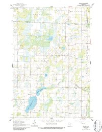
1961 Map of Dalbo
USGS Topo · Published 1986About this map
Glacial wetland features and rural social hubs define this part of the Kanabec and Isanti County border area in the early 1960s. The settlement of Dalbo serves as a focal point, supported by vital community institutions like the Grange Hall, Lincoln School, and the Dalbo Cemetery. To the west, the landscape is heavily influenced by stagnant water and peat formations such as Krone Bog and Odegard Bog, while the southern reaches are dominated by the hydrologic connection between North Stanchfield Lake and South Stanchfield Lake. This map captures a dispersed agricultural network where isolated landmarks, such as North Star School and the Karmel Church, reveal the footprint of early Scandinavian-influenced settlement across the Minnesota countryside.
Find a feature on this map
34 named features on this map. Tap any name to fly to it.
Don’t see what you’re looking for? This feature index may not catch every label — zoom into the map to look around manually.
Map Details
Editions of this 1961 Dalbo Map
2 editions found
Other maps of this area

1953 · Stillwater
USGS Topo · 1:250,000

1955 · Stillwater
USGS Topo · 1:250,000

1958 · Stillwater
USGS Topo · 1:250,000

1961 · Bradford
USGS Topo · 1:24,000

1961 · Springvale
USGS Topo · 1:24,000

1961 · Dalbo
USGS Topo · 1:24,000

1961 · Wyanett
USGS Topo · 1:24,000

1961 · Dalbo
USGS Topo · 1:62,500

1965 · Stillwater
USGS Topo · 1:250,000
1968 · Princeton
USGS Topo · 1:24,000