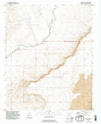
1991 Map of Dalies NW
USGS Topo · Published 1996About this map
The Rio Puerco (Approx) winds through a landscape defined by ancestral boundaries and expansive land grants in this high-desert region of Bernalillo County. The terrain is marked by significant territorial divisions, where the Antonio Sedillo Grant and Pajarito Grant meet the Isleta Pueblo Indian Reservation. Evidence of local ranching and water management is visible through scattered landmarks such as a Windmill, a Corral, and a Community Well, all essential for sustaining life and livestock in this arid environment.
Find a feature on this map
14 named features on this map. Tap any name to fly to it.
Don’t see what you’re looking for? This feature index may not catch every label — zoom into the map to look around manually.
Map Details
Editions of this 1991 Dalies NW Map
This is the sole edition of this map. No revisions or reprints were ever made.
Other maps of this area

1883 · Mt. Taylor
USGS Topo · 1:250,000

1886 · Mt. Taylor
USGS Topo · 1:250,000

1888 · Bernalillo
USGS Topo · 1:125,000

1889 · Albuquerque
USGS Topo · 1:125,000

1892 · Mt. Taylor
USGS Topo · 1:250,000

1893 · Albuquerque
USGS Topo · 1:125,000

1899 · Mt. Taylor
USGS Topo · 1:250,000

1917 · Cerro Verde
USGS Topo · 1:125,000

1952 · Wind Mesa
USGS Topo · 1:24,000

1952 · Dalies
USGS Topo · 1:24,000