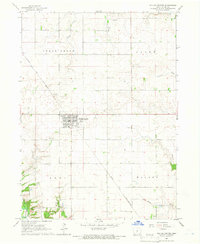
1965 Map of Dallas Center
USGS Topo · Published 1966About this map
Dallas Center occupies the heart of this central Iowa landscape, organized around the diagonal path of the Chicago and North Western railroad. Surveyed in the mid-1960s, the map reveals a predominantly agricultural area defined by the townships of Sugar Grove, Grant, Adel, and Walnut. The terrain is characterized by a network of drainage features including Slough Creek, Royer Creek, and the winding Walnut Creek, which flows toward the Raccoon R in the southwestern corner.
Find a feature on this map
20 named features on this map. Tap any name to fly to it.
Don’t see what you’re looking for? This feature index may not catch every label — zoom into the map to look around manually.
Map Details
Editions of this 1965 Dallas Center Map
This is the sole edition of this map. No revisions or reprints were ever made.
Other maps of this area

1908 · Waukee
USGS Topo · 1:62,500

1911 · Madrid
USGS Topo · 1:62,500

1914 · Madrid
USGS Topo · 1:62,500

1949 · Adel
USGS Topo · 1:62,500

1950 · Perry
USGS Topo · 1:62,500

1951 · Perry
USGS Topo · 1:62,500

1951 · Adel
USGS Topo · 1:62,500

1954 · Omaha
USGS Topo · 1:250,000

1954 · Des Moines
USGS Topo · 1:250,000

1956 · Des Moines
USGS Topo · 1:250,000