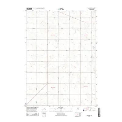
2015 Map of Dallas NW
USGS Topo · Published 2015About this map
Ponca Cr winds through this rural landscape in northern Tripp County, defining the drainage patterns of a region deeply shaped by the Public Land Survey System. The map reveals a strict grid of section lines and gravel roads, such as 287th St and 324th Ave, which partition the prairie into township blocks like T97n R75w and T96n R74w. While the terrain is largely dedicated to agriculture and open range, localized water features like Roosevelt Lake provide contrast to the surrounding upland contours. Modern transportation is anchored by the corridor of highway 183, which bisects the western half of the quadrangle. This 2015 survey reflects the enduring character of the South Dakota plains, where the vast majority of the land remains divided for agricultural use according to century-old survey standards.
Find a feature on this map
23 named features on this map. Tap any name to fly to it.
Don’t see what you’re looking for? This feature index may not catch every label — zoom into the map to look around manually.
Map Details
Editions of this 2015 Dallas NW Map
This is the sole edition of this map. No revisions or reprints were ever made.
Other maps of this area

1955 · Mitchell
USGS Topo · 1:250,000

1959 · Mitchell
USGS Topo · 1:250,000

1964 · Dallas SW
USGS Topo · 1:24,000

1964 · Dallas
USGS Topo · 1:24,000

1964 · Paxton
USGS Topo · 1:24,000

1964 · Dallas NW
USGS Topo · 1:24,000

1971 · Colome
USGS Topo · 1:24,000

1971 · Colome SE
USGS Topo · 1:24,000
1982 · Wewela
USGS Topo · 1:24,000

1982 · Winner South
USGS Topo · 1:25,000