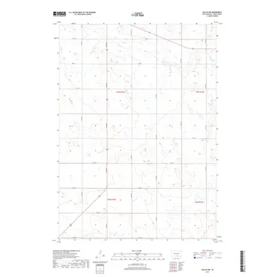
2017 Map of Dallas NW
USGS Topo · Published 2017About this map
Ponca Cr winds through this rural section of Tripp County, defining a landscape of intermittent drainage and rolling topography. The area is dominated by a systematic grid of section roads and section lines, with Hwy 31 serving as a primary north-south corridor. In the northeast, Roosevelt Lake stands as a localized water feature within an otherwise semi-arid agricultural setting. This 2017 survey reflects the enduring land patterns of the High Plains, where the Public Land Survey System continues to dictate the placement of roads like 295th St and 327th Ave. The map offers a precise view of the drainage basin for the Ponca, illustrating the complex network of draws and seasonal wetlands that characterize this part of South Dakota.
Find a feature on this map
21 named features on this map. Tap any name to fly to it.
Don’t see what you’re looking for? This feature index may not catch every label — zoom into the map to look around manually.
Map Details
Editions of this 2017 Dallas NW Map
This is the sole edition of this map. No revisions or reprints were ever made.
Other maps of this area

1955 · Mitchell
USGS Topo · 1:250,000

1959 · Mitchell
USGS Topo · 1:250,000

1964 · Dallas SW
USGS Topo · 1:24,000

1964 · Dallas
USGS Topo · 1:24,000

1964 · Paxton
USGS Topo · 1:24,000

1964 · Dallas NW
USGS Topo · 1:24,000

1971 · Colome
USGS Topo · 1:24,000

1971 · Colome SE
USGS Topo · 1:24,000
1982 · Wewela
USGS Topo · 1:24,000

1982 · Winner South
USGS Topo · 1:25,000