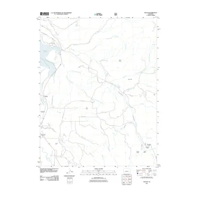
2011 Map of Dallas
USGS Topo · Published 2011About this map
The Uncompahgre River valley dominates this portion of the western slope, where the small settlement of Dallas serves as a local landmark. A complex network of water management features, including the Alkali Ditch Number 1 and Alkali Ditch Number 2, reveals the region's historical reliance on irrigation to support local agriculture and industry. Mining history is preserved on the landscape at the Uncompahgre Placer Mine and the Fortuna Mine, reflecting the mineral extraction that helped shape the county. Significant water bodies like Ridgeway Reservoir and Victor Reservoir are prominent, while the Ouray County Fairground marks a center for community gathering. To the southeast, the terrain becomes increasingly complex with features like Ramshorn Ridge and various gulches such as Bear Gulch, while natural geothermal activity is represented by the Orvis Hot Spring.
Find a feature on this map
55 named features on this map. Tap any name to fly to it.
Don’t see what you’re looking for? This feature index may not catch every label — zoom into the map to look around manually.
Map Details
Editions of this 2011 Dallas Map
This is the sole edition of this map. No revisions or reprints were ever made.
Other maps of this area

1902 · Ouray
USGS Topo · 1:62,500

1904 · Ouray
USGS Topo · 1:62,500

1909 · Montrose
USGS Topo · 1:125,000

1911 · Montrose
USGS Topo · 1:125,000

1955 · Ouray
USGS Topo · 1:24,000

1956 · Montrose
USGS Topo · 1:250,000

1959 · Montrose
USGS Topo · 1:250,000

1960 · Montrose
USGS Topo · 1:250,000
1963 · Buckhorn Lakes
USGS Topo · 1:24,000
1963 · Courthouse Mountain
USGS Topo · 1:24,000