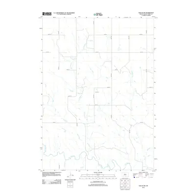
2012 Map of Dallas SW
USGS Topo · Published 2012About this map
The Keya Paha River snakes through the southern reaches of this landscape, fed by a network of drainage systems including Holt Cr and Jimmie Cr. This section of Tripp County is defined by its rural grid of section-line roads, such as 324th Ave and 300th St, which organize the rolling prairie into distinct parcels. A primary landmark for local historians is the Gibson Cem, situated near the center of the quadrangle along 324th Ave. This cemetery serves as a focal point for genealogical interest in an area otherwise characterized by its agricultural rhythm and watercourses. Other notable streams like Rock Bridge Cr and Deer Cr carve through the terrain, illustrating the natural watershed patterns that have dictated land use and settlement since the earliest township surveys.
Find a feature on this map
20 named features on this map. Tap any name to fly to it.
Don’t see what you’re looking for? This feature index may not catch every label — zoom into the map to look around manually.
Map Details
Editions of this 2012 Dallas SW Map
This is the sole edition of this map. No revisions or reprints were ever made.
Other maps of this area

1955 · Mitchell
USGS Topo · 1:250,000

1955 · O'Neill
USGS Topo · 1:250,000

1959 · O'Neill
USGS Topo · 1:250,000

1959 · Mitchell
USGS Topo · 1:250,000

1964 · Dallas SW
USGS Topo · 1:24,000

1964 · Dallas
USGS Topo · 1:24,000

1964 · Paxton
USGS Topo · 1:24,000
1964 · Burton
USGS Topo · 1:24,000
1964 · Springview NW
USGS Topo · 1:24,000

1964 · Dallas NW
USGS Topo · 1:24,000