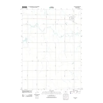
2012 Map of Dallas
USGS Topo · Published 2012About this map
Dallas Cemetery and Hillview Cemetery sit north of the township, which is neatly gridded by streets like Taylor Ave and Tripp Ave. This portion of Gregory County is defined by the winding path of Ponca Creek, which meanders eastward through the central portion of the landscape. The rural section roads, including Viaduct Rd and 330th Ave, provide a geometric contrast to the natural curves of the creek bed. To the south, the Zion Lutheran Cemetery stands as a notable landmark for those tracing local family histories. Smaller water features such as Lake Dalton and Roosevelt Lake break the expanse of the prairie, while Bull Creek drains the northern edge of the territory near County Highway 6.
Find a feature on this map
35 named features on this map. Tap any name to fly to it.
Don’t see what you’re looking for? This feature index may not catch every label — zoom into the map to look around manually.
Map Details
Editions of this 2012 Dallas Map
This is the sole edition of this map. No revisions or reprints were ever made.
Other maps of this area

1955 · Mitchell
USGS Topo · 1:250,000

1959 · Mitchell
USGS Topo · 1:250,000

1964 · Dallas SW
USGS Topo · 1:24,000

1964 · Gregory
USGS Topo · 1:24,000

1964 · Dallas
USGS Topo · 1:24,000

1964 · Paxton
USGS Topo · 1:24,000

1964 · Dallas NW
USGS Topo · 1:24,000
1964 · Carlock
USGS Topo · 1:24,000

1971 · Colome
USGS Topo · 1:24,000

1971 · Dixon SW
USGS Topo · 1:24,000