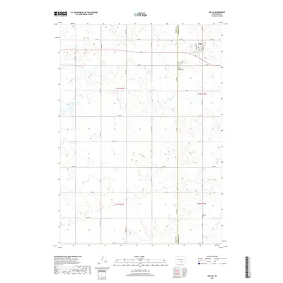
2017 Map of Dallas
USGS Topo · Published 2017About this map
Dallas sits at the northern edge of this high-plains landscape, established near the border of Tripp and Gregory Counties. The township structure is defined by a rigorous grid of section-line roads such as 287th St and 290th St, which navigate the undulating drainage basins of Ponca Creek and Bull Cr. For genealogists, the map identifies several critical burial sites, including the Dallas Cem, Hillview Cem, and the Saint Augustine Catholic Cem located just south of the main town site. Further south, the Zion Lutheran Cem marks a more isolated community center along County Road 7. The hydrology of the region is punctuated by small prairie water bodies like Roosevelt Lake and Lake Dolton, which provide local landmarks amidst a vast network of section-bound ranching and agricultural land in the late 2010s.
Find a feature on this map
40 named features on this map. Tap any name to fly to it.
Don’t see what you’re looking for? This feature index may not catch every label — zoom into the map to look around manually.
Map Details
Editions of this 2017 Dallas Map
This is the sole edition of this map. No revisions or reprints were ever made.
Other maps of this area

1955 · Mitchell
USGS Topo · 1:250,000

1959 · Mitchell
USGS Topo · 1:250,000

1964 · Dallas SW
USGS Topo · 1:24,000

1964 · Gregory
USGS Topo · 1:24,000

1964 · Dallas
USGS Topo · 1:24,000

1964 · Paxton
USGS Topo · 1:24,000

1964 · Dallas NW
USGS Topo · 1:24,000
1964 · Carlock
USGS Topo · 1:24,000

1971 · Colome
USGS Topo · 1:24,000

1971 · Dixon SW
USGS Topo · 1:24,000