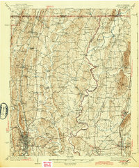
1897 Map of Dalton
USGS Topo · Published 1913About this map
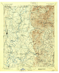
Dalton stands as a vital rail junction in North Georgia, where the Western and Atlantic R. R. and Southern Ry. converge at the foot of the Blue Ridge foothills. This late-19th-century landscape is defined by its dependence on the winding Conasauga River, which served as a natural thoroughfare for freight and travel. The map meticulously documents a river-based economy that relied on numerous crossings, such as Tibbs Bridge and the Ford and Ferry, to connect the fertile valleys with the higher elevations of Cohutta Mountain and Fort Mountain.
Find a feature on this map
157 named features on this map. Tap any name to fly to it.
Don’t see what you’re looking for? This feature index may not catch every label — zoom into the map to look around manually.
Map Details
Editions of this 1897 Dalton Map
4 editions found

Historical Maps of Dalton Through Time
6 maps found