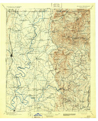
1897 Map of Dalton
USGS Topo · Published 1931About this map
The Conasauga River and its complex network of tributaries anchor this late 19th-century study of the Georgia-Tennessee border region. The landscape is defined by the sharp transition between the agricultural valleys surrounding Dalton and the steep ridges of the Cohutta Mountains. This era relied heavily on river crossings, evidenced by numerous historical transit points such as the Old Chattanooga Ford, Montgomery Ferry, and Shackleford Ferry. Early industrial sites like Praters Mill and Hassler Mill sit alongside the rail corridors of the Western and Atlantic RR, illustrating a period when water power and steam rail were both critical to local commerce. In the eastern uplands, isolated gaps like Alaculsy Gap and peaks such as Fort Mountain overlook a network of small settlements including Spring Place and Cohutta Springs.
Find a feature on this map
152 named features on this map. Tap any name to fly to it.
Don’t see what you’re looking for? This feature index may not catch every label — zoom into the map to look around manually.
Map Details
Editions of this 1897 Dalton Map
4 editions found

Other maps of this area

1886 · Dalton
USGS Topo · 1:125,000

1886 · Cleveland
USGS Topo · 1:125,000

1886 · Ringgold
USGS Topo · 1:125,000

1886 · Rome
USGS Topo · 1:125,000

1888 · Ellijay
USGS Topo · 1:125,000

1888 · Chattanooga
USGS Topo · 1:125,000

1890 · Suwanee
USGS Topo · 1:125,000

1890 · Cartersville
USGS Topo · 1:125,000

1891 · Cartersville
USGS Topo · 1:125,000

1892 · Ringgold
USGS Topo · 1:125,000