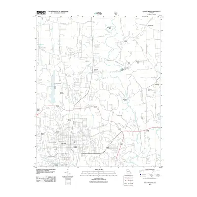
2011 Map of Dalton North
USGS Topo · Published 2011About this map
Dalton's northern expansion and its surrounding Whitfield County landscape are documented here at a time of significant residential and commercial development. The city's northern neighborhoods, including Fort Hill and Cannon Heights, show a dense street grid that transitions into the more rural character of Waring and Pleasant Grove. Industrial and logistical activity is anchored by the Dalton Quarry and the Dalton Post Office, while the natural topography is defined by the prominent Mount Rachel and Hamilton Mountain.
Find a feature on this map
99 named features on this map. Tap any name to fly to it.
Don’t see what you’re looking for? This feature index may not catch every label — zoom into the map to look around manually.
Map Details
Editions of this 2011 Dalton North Map
This is the sole edition of this map. No revisions or reprints were ever made.
Other maps of this area

1886 · Dalton
USGS Topo · 1:125,000

1886 · Ringgold
USGS Topo · 1:125,000

1892 · Ringgold
USGS Topo · 1:125,000

1892 · Dalton
USGS Topo · 1:125,000

1897 · Dalton
USGS Topo · 1:125,000
1935 · Tiger Creek
USGS Topo · 1:24,000

1935 · Villanow
USGS Topo · 1:24,000

1935 · Ringgold
USGS Topo · 1:24,000

1935 · Tunnel Hill
USGS Topo · 1:24,000

1938 · Chatsworth
USGS Topo · 1:48,000