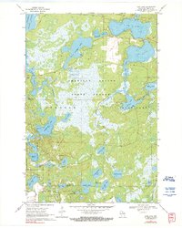
1970 Map of Dam Lake
USGS Topo · Published 1990About this map
The American Legion State Forest dominates this northern Wisconsin landscape, revealing a complex glaciated terrain defined by an intricate network of waterways and wetlands. At the heart of the region, the Rainbow Flowage and the expansive waters of Dam Lake characterize the local hydrography, connected by seasonal flows like Sugar Camp Creek and Indian Creek. This 1970 survey captures the area during a period of established conservation and recreational use, as evidenced by several Boat Ramps and the preservation of large forest tracts. Smaller, specifically named water bodies such as Jenny Barnes Lake, Tom Doyle Lake, and Kate Pier Lake suggest the deep-rooted local history of family names tied to the shoreline. The inclusion of a Cranberry Bog south of North Nokomis Lake highlights the regional agricultural specialization in peat-rich lowlands, while a solitary Gravel Pit near Sand Lake points to the localized industry of the era.
Find a feature on this map
38 named features on this map. Tap any name to fly to it.
Don’t see what you’re looking for? This feature index may not catch every label — zoom into the map to look around manually.
Map Details
Editions of this 1970 Dam Lake Map
2 editions found
Other maps of this area

1930 · Robbins
USGS Topo · 1:48,000

1938 · Minocqua
USGS Topo · 1:48,000

1938 · Robbins
USGS Topo · 1:48,000

1939 · Cassian
USGS Topo · 1:48,000

1940 · Rhinelander
USGS Topo · 1:48,000

1942 · Cassian
USGS Topo · 1:48,000

1945 · Robbins
USGS Topo · 1:48,000

1946 · Minocqua
USGS Topo · 1:48,000

1949 · Rhinelander
USGS Topo · 1:48,000

1949 · Minocqua
USGS Topo · 1:48,000