2023 Map of Damascus
USGS Topo · Published 2023About this map
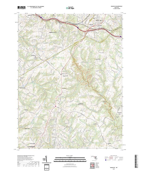
The headwaters of the Patuxent River and Great Seneca Creek converge in this corner of Maryland, where four counties meet near the high ground of Damascus. This modern survey reveals a landscape still defined by the crossroads of historical thoroughfares like the Old National Pike and Main St. Settlement patterns follow the ridge lines, with rural communities such as Claggettsville, Kemptown, and Mullinix serving as local anchors. Religious and community history is well-preserved through numerous landmarks, including Providence United Methodist Church and the Marvin Chapel Cem. The transition from the northern reaches of Clarksburg to the southern edge of Mount Airy shows a terrain carved by numerous tributaries, including Bennett Creek and the South Branch Patapsco River, illustrating the complex drainage systems that define this central Maryland plateau.
Find a feature on this map
44 named features on this map. Tap any name to fly to it.
Don’t see what you’re looking for? This feature index may not catch every label — zoom into the map to look around manually.
Map Details
Editions of this 2023 Damascus Map
This is the sole edition of this map. No revisions or reprints were ever made.
Other maps of this area

1893 · Frederick
USGS Topo · 1:125,000

1894 · Frederick
USGS Topo · 1:125,000

1908 · Rockville
USGS Topo · 1:62,500

1908 · Seneca
USGS Topo · 1:62,500

1908 · Ijamsville
USGS Topo · 1:62,500

1909 · Mount Airy
USGS Topo · 1:62,500

1909 · Ijamsville
USGS Topo · 1:62,500

1923 · Rockville
USGS Topo · 1:62,500

1942 · Frederick
USGS Topo · 1:62,500
1944 · Walkersville
USGS Topo · 1:31,680