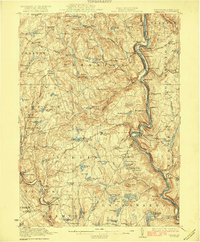
1923 Map of Damascus
USGS Topo · Published 1923About this map
The winding Upper Delaware River forms a natural boundary between Pennsylvania and New York in this early 1920s topographical study. Centered on Damascus and Cochecton, the map reveals a rural landscape defined by steep ridges and an abundance of highland waters such as Duck Harbor Pond and Welcome Lake. The Erie RR follows the river's tight curves, connecting riverside settlements like Narrowsburg and Skinners Falls with the interior.
Find a feature on this map
131 named features on this map. Tap any name to fly to it.
Don’t see what you’re looking for? This feature index may not catch every label — zoom into the map to look around manually.
Map Details
Editions of this 1923 Damascus Map
5 editions found
Other maps of this area

1892 · Honesdale
USGS Topo · 1:62,500

1913 · Milford
USGS Topo · 1:62,500

1915 · Milford
USGS Topo · 1:62,500

1920 · Long Eddy
USGS Topo · 1:62,500

1920 · Damascus
USGS Topo · 1:62,500

1921 · Long Eddy
USGS Topo · 1:48,000

1921 · Livingston Manor
USGS Topo · 1:62,500

1922 · White Lake
USGS Topo · 1:62,500

1923 · Damascus
USGS Topo · 1:62,500

1923 · Long Eddy
USGS Topo · 1:62,500