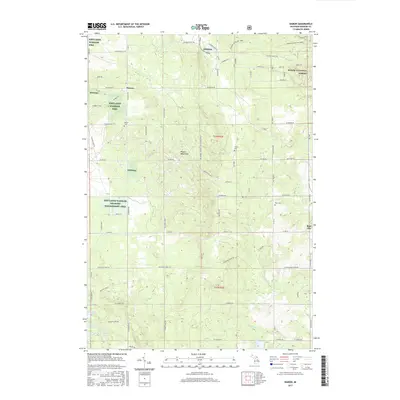
2017 Map of Damon
USGS Topo · Published 2017About this map
Damon and the northwestern outskirts of Rose City anchor this Ogemaw County landscape, which is defined by a dense network of forest trails and managed wildlife habitats. Much of the western half is dedicated to the Kirtlands Warbler Wildlife Management Area, a specialized conservation tract adjacent to the Huron National Forest. The terrain transitions from the wetland environments of Tamarack Swamp and Wallin Lake in the southwest toward the elevation of Wagon Wheel Hill in the center. Genealogists will find several small burial sites, including Damon Cem, Tucker Cem, and Rose Cem, situated along the section lines and secondary routes like N Fairview Rd and Co Rd 22. Numerous small tributaries such as Houghton Creek, Brooks Cr, and Prior Cr drain the glacial topography, illustrating the hydrologic patterns of Michigan's northern Lower Peninsula.
Find a feature on this map
78 named features on this map. Tap any name to fly to it.
Don’t see what you’re looking for? This feature index may not catch every label — zoom into the map to look around manually.
Map Details
Editions of this 2017 Damon Map
This is the sole edition of this map. No revisions or reprints were ever made.
Other maps of this area

1954 · Traverse City
USGS Topo · 1:250,000

1958 · Traverse City
USGS Topo · 1:250,000

1963 · Luzerne
USGS Topo · 1:24,000

1965 · Damon
USGS Topo · 1:24,000

1965 · St. Helen NE
USGS Topo · 1:24,000

1965 · West Branch
USGS Topo · 1:24,000

1965 · Ogemaw Springs
USGS Topo · 1:24,000

1965 · Selkirk
USGS Topo · 1:24,000

1965 · Rose City
USGS Topo · 1:24,000

1972 · Mack Lake
USGS Topo · 1:24,000