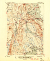
1943 Map of Danforth
USGS Topo · Published 1946About this map
Danforth serves as the central hub of this northern Maine landscape, where the Canadian Pacific railroad intersects with the winding Baskahegan Stream. Surveyed in the late 1930s, the map reveals a remote territory of ridges and interior waterways, defined by the international border at Chiputneticook Lakes. The settlement pattern reflects a rugged rural economy, with numerous small schools like Ridge Sch and Bonner Sch serving isolated communities. Cultural markers such as the Irish Settlement and Trout Brook Cem provide specific points of interest for genealogists tracing family ties to the Aroostook and Washington county line. The western portion is dominated by the heights of Stetson Mountain and the logging camps that dot the drainage basins, including West Branch Camp and Muncey Camp, illustrating the region's historical reliance on timber and water-powered transport before modern infrastructure transformed the Maine north woods.
Find a feature on this map
137 named features on this map. Tap any name to fly to it.
Don’t see what you’re looking for? This feature index may not catch every label — zoom into the map to look around manually.
Map Details
Editions of this 1943 Danforth Map
3 editions found

Other maps of this area

1931 · Springfield
USGS Topo · 1:48,000

1934 · Springfield
USGS Topo · 1:62,500

1940 · Danforth
USGS Topo · 1:62,500

1940 · Amity
USGS Topo · 1:62,500

1940 · Waite
USGS Topo · 1:62,500

1940 · Forest
USGS Topo · 1:62,500

1941 · Danforth
USGS Topo · 1:62,500

1941 · Amity
USGS Topo · 1:62,500

1941 · Scraggly Lake
USGS Topo · 1:62,500

1941 · Mattawamkeag Lake
USGS Topo · 1:62,500