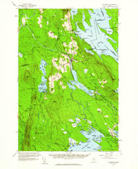
1958 Map of Danforth
USGS Topo · Published 1960About this map
Baskakegan Stream and the sprawling waters of Chiputneticook Lakes dominate this late 1950s interior landscape along the international border. The town of Danforth serves as the primary hub, situated at the junction of the Maine Central and Canadian Pacific railroads. This intersection of rail lines highlights the area's importance as a transit corridor for timber and goods between the United States and Canada.
Find a feature on this map
169 named features on this map. Tap any name to fly to it.
Don’t see what you’re looking for? This feature index may not catch every label — zoom into the map to look around manually.
Map Details
Editions of this 1958 Danforth Map
3 editions found
Other maps of this area

1931 · Springfield
USGS Topo · 1:48,000

1934 · Springfield
USGS Topo · 1:62,500

1940 · Danforth
USGS Topo · 1:62,500

1940 · Amity
USGS Topo · 1:62,500

1940 · Waite
USGS Topo · 1:62,500

1940 · Forest
USGS Topo · 1:62,500

1941 · Danforth
USGS Topo · 1:62,500

1941 · Amity
USGS Topo · 1:62,500

1941 · Scraggly Lake
USGS Topo · 1:62,500

1941 · Mattawamkeag Lake
USGS Topo · 1:62,500