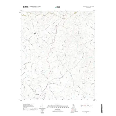
2020 Map of Danielsville North
USGS Topo · Published 2020About this map
The Hudson River and Broad River converge in this northeast Georgia landscape, defining a rural terrain marked by long-standing agricultural settlements and family-named landmarks. The northern outskirts of Danielsville anchor the southern portion of the map, while small crossroads like Bond, Shiloh, and Harrison remain central to the local geography. This area is characterized by a dense network of country roads, many bearing family names such as Elridge Crowe Rd and Andrews Adams Rd, reflecting generations of local land ownership. Significant cultural sites include Macedonia Church and New Haven Church, alongside family burial grounds like Ware Cem and Adams Cem. The naming of waterways such as Masons Mill Cr and Scull Shoal Cr suggests a history of small-scale industry and milling along the tributary creeks that feed into the larger river systems.
Find a feature on this map
119 named features on this map. Tap any name to fly to it.
Don’t see what you’re looking for? This feature index may not catch every label — zoom into the map to look around manually.
Map Details
Editions of this 2020 Danielsville North Map
This is the sole edition of this map. No revisions or reprints were ever made.
Other maps of this area

1891 · Carnesville
USGS Topo · 1:125,000

1954 · Greenville
USGS Topo · 1:250,000

1958 · Greenville
USGS Topo · 1:250,000

1958 · Danielsville
USGS Topo · 1:62,500

1959 · Carnesville
USGS Topo · 1:24,000

1959 · Royston
USGS Topo · 1:24,000

1964 · Ila
USGS Topo · 1:24,000

1964 · Ashland
USGS Topo · 1:24,000

1964 · Hull
USGS Topo · 1:24,000
1972 · Danielsville South
USGS Topo · 1:24,000