
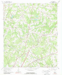
1964 Map of Hull
USGS Topo · Published 1965About this map
The Seaboard Air Line railroad anchors the southern landscape of this mid-1960s survey, passing through the town of Hull near the intersection of Old Elberton Road. The terrain is defined by the branching tributaries of Sandy Creek and the South Fork, which carve through a mosaic of woodlots and small agricultural clearings. Local social life is evidenced by a high density of rural institutions, such as Moon Grove Ch, Gordons Chapel, and the Pleasant Grove Community Center at Neese. Genealogists will find several family-named burial sites including Porterfield Cem and Chandler Cem. In the north, small settlements like Planter and Fairplay sit among the headwaters of the North Fork Double Branch, while the western edge is marked by Lake Seagraves and the winding course of Nowhere Creek.
Find a feature on this map
51 named features on this map. Tap any name to fly to it.
Don’t see what you’re looking for? This feature index may not catch every label — zoom into the map to look around manually.
Map Details
Editions of this 1964 Hull Map
2 editions found
Other maps of this area

1891 · Carnesville
USGS Topo · 1:125,000

1953 · Athens
USGS Topo · 1:250,000

1954 · Greenville
USGS Topo · 1:250,000

1958 · Greenville
USGS Topo · 1:250,000

1958 · Athens
USGS Topo · 1:250,000

1958 · Danielsville
USGS Topo · 1:62,500

1959 · Athens
USGS Topo · 1:250,000

1963 · Athens
USGS Topo · 1:250,000

1964 · Commerce
USGS Topo · 1:24,000

1964 · Athens West
USGS Topo · 1:24,000