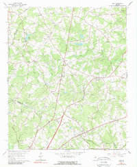
1964 Map of Hull
USGS Topo · Published 1989About this map
The Seaboard Air Line railroad cuts a diagonal path across the landscape near Hull, serving as a primary corridor for transportation and trade in this corner of Madison County. This mid-1960s landscape is characterized by a dense network of rural churches and family cemeteries, suggesting a deeply rooted community structure. Significant landmarks such as Gordons Chapel, Sacred Heart Camp, and Barretts Mill populate the terrain between the numerous branches of Sandy Creek.
Find a feature on this map
59 named features on this map. Tap any name to fly to it.
Don’t see what you’re looking for? This feature index may not catch every label — zoom into the map to look around manually.
Map Details
Editions of this 1964 Hull Map
2 editions found

Other maps of this area

1891 · Carnesville
USGS Topo · 1:125,000

1953 · Athens
USGS Topo · 1:250,000

1954 · Greenville
USGS Topo · 1:250,000

1958 · Greenville
USGS Topo · 1:250,000

1958 · Athens
USGS Topo · 1:250,000

1958 · Danielsville
USGS Topo · 1:62,500

1959 · Athens
USGS Topo · 1:250,000

1963 · Athens
USGS Topo · 1:250,000

1964 · Commerce
USGS Topo · 1:24,000

1964 · Athens West
USGS Topo · 1:24,000