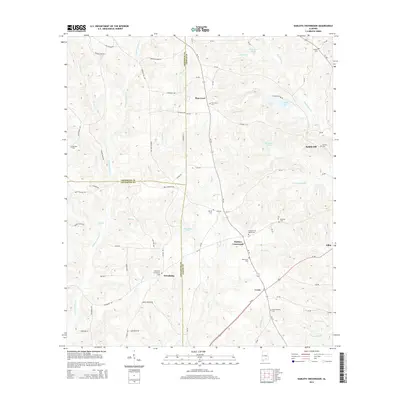
2014 Map of Danleys Crossroads
USGS Topo · Published 2014About this map
Danleys Crossroads and Pine Level serve as central nodes in this rural portion of Alabama, where the borders of Coffee, Covington, and Crenshaw counties converge. The landscape is defined by a dense network of watercourses, including Lightwood Knot Cr, Mill Cr, and Beaverdam Cr, which carve through the terrain and support local landmarks like Donaldson Pond and County Lake. For family historians, the area is well-marked by numerous legacy burial grounds such as Pine Level Cem, Friendship Community Cem, and the New Ebenezer Cem near the settlement of Curtis. Local industry and rural infrastructure are reflected in features like Danleys Mill Br and Helms Mill Cr, while the winding road network includes the descriptively named Old Union Rd and Bell Crossing Rd.
Find a feature on this map
92 named features on this map. Tap any name to fly to it.
Don’t see what you’re looking for? This feature index may not catch every label — zoom into the map to look around manually.
Map Details
Editions of this 2014 Danleys Crossroads Map
This is the sole edition of this map. No revisions or reprints were ever made.
Other maps of this area

1953 · Andalusia
USGS Topo · 1:250,000

1957 · Andalusia
USGS Topo · 1:250,000

1968 · Danleys Crossroads
USGS Topo · 1:24,000
1968 · Ino
USGS Topo · 1:24,000
1968 · Bluff Springs
USGS Topo · 1:24,000

1968 · Opp East
USGS Topo · 1:24,000
1968 · Elba
USGS Topo · 1:24,000

1968 · Bullock
USGS Topo · 1:24,000

1971 · Dozier
USGS Topo · 1:24,000

1971 · Brantley
USGS Topo · 1:24,000