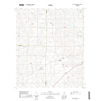
2018 Map of Danleys Crossroads
USGS Topo · Published 2018About this map
Danleys Crossroads anchors this rural landscape at the intersection of three Alabama counties, where the borders of Crenshaw, Coffee, and Covington meet. This area, recorded in the late 2010s, is defined by small agricultural clusters and a network of family-named water bodies and burial grounds. The settlement of Pine Level and the community of Friendship are connected by a web of county roads that navigate the headwaters of Lightwood Knot Cr and Pond Cr. Local history is preserved in numerous scattered sites such as Friendship Community Cem and New Ebenezer Cem, which sit alongside established water features like County Lake and Whitman Pond. To the east, the map reaches the periphery of Elba, showing the transition from the winding creek bottoms of Beaverdam Cr and Coon Cr toward more concentrated development.
Find a feature on this map
88 named features on this map. Tap any name to fly to it.
Don’t see what you’re looking for? This feature index may not catch every label — zoom into the map to look around manually.
Map Details
Editions of this 2018 Danleys Crossroads Map
This is the sole edition of this map. No revisions or reprints were ever made.
Other maps of this area

1953 · Andalusia
USGS Topo · 1:250,000

1957 · Andalusia
USGS Topo · 1:250,000

1968 · Danleys Crossroads
USGS Topo · 1:24,000
1968 · Ino
USGS Topo · 1:24,000
1968 · Bluff Springs
USGS Topo · 1:24,000

1968 · Opp East
USGS Topo · 1:24,000
1968 · Elba
USGS Topo · 1:24,000

1968 · Bullock
USGS Topo · 1:24,000

1971 · Dozier
USGS Topo · 1:24,000

1971 · Brantley
USGS Topo · 1:24,000